


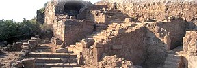
Adanda Lamus
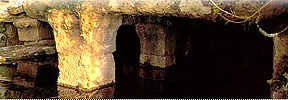
 It is 55 km to the east of Alanya and 2 km to the north of Adanda Village. The city is situated on the two hills constituting the peak of a steep mountain. It is understood from the inscription at the entrance gate of the city that the hill on the west was surrounded by city walls in Gallienus’s time, in the middle of 3th century A.D. The gate of the city is protected by a big tower. There are some remnants of a second city wall inside the main city walls. In the flat land between the two hills one can see the ruins of the agora, fountain and the temple of the city. One of the two temples of the city was built on behalf of Roman emperors Vespasianus, and the other on behalf of Titus. On the estern hill however, one can see the rooms carved into the rocks and the necropolis with big tombs. Entrance is free.
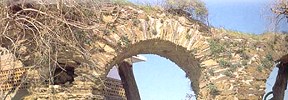
Antiocheia Ad Cragum
 60 km. to the east of Alanya. On the Mediterranean coast, in the Mountainous Kilikya. The city got its name after King of Kommagene Antiochus IV who lived in 1st century A.D. The ruins of the city are located on three hills. In the first part there is a colonnaded street, an agora, a bath, an arch of triumph and some ruins of a church. The second part is the necropolis where there are graves typical to Kilikya region. The third part consists of ruins of a Middle Age fortress on a rocky fielld extending to the sea. To the north of the city there are the ruins of a temple where the architectural elements can easily be seen. In the city centre, there is a building called Triconchos whose three walls were made in apsis shape and supposed to have had religious function. Entrance is free. Seeing all the ruins takes nearly two hours.
Hamaxia
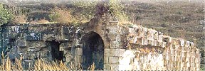
 It is 12 kilometres far from Alanya. Within the borders of Pamphylia Region. Strabon, the eminent geographer of the antiqity, mentions that the timber used in ship building was grown in the town and particularly there were cedar trees in the town. It is believed that the town was founded before Roman period. Rectangular stone shaped tower shows Hellenistic features. The most important ruins of the town include; an antique fountain. Pool, semicircle designed, excedra whose seat are still seen still readable inscriptions, religious complex and necropolis. Some inscriptions discovered in the town pave emblem of Hermes which indicates existence of Hermes temple in the town. Considerable parts of an embossed otel Ostoteks exhibited in the Alanya Museum were discovered in the town. It is known that a small community not being rich lived in Hamaxia between A.D. 100 and 200 under reign of Coracesium. Important part of the ruins are dated from Roman and Byzantine Period. It is free to visit this site. It has a nice view of Alanya from he slope that faces the sea. When there is no mist, it is possible to see that coast which is more than 100 km between Gazipaşa and Manavgat.
Iotape
 It is 33 km. to the east of Alanya, on the coast. The antique city got its name from Iotape, wife of Antiochus 4 of Kommagene king (A.D. 38-72). The city printed its owner coin during the period from Emperor Trianus to Valerianus. The ruins have features of Roman and Byzantine Period. The acropolis of the city is the high hill extending to the sea. The castle walls gives appearance of castle. The buildings are destroyed considerably. In the valley where acropolis is connected to the land, there is Harbour street extending in east and west direction. On both sides of the street, there are crepis consisting of three steps and fundamentals for sculptures.
Leartes
Located about 25 km. away from Alanya, on the skirt of a mountain elevating at the entrance of Dim Valley on Taurus Mountains. The city takes place in the border of the region known as Mountainous Kilikya Region in antique age. Although it spread inland it also has a harbour. Inscription dating the own from B.C. 7th century in Fenike language and found in the town is exhibited in the alanya museum. The important ruins of the town remaining at present are observatory towers, Caracalla excedra, odeon or theatre, Zeus Megistos temple, Apollon temple, Caesar temple, agora, bath and necropolis. According to the inscriptions that are available, this area lived its best period between the first and third centuries. Other important art discovered in the town is ‘diploma of a Roman soldier’ being exhibited in the Alanya Museum, which gives information about military aspect of the town. The ruins are dated from Roman period. Visit to the site is free.
Nephelis
 It is on a high hill streching to the sea that takes place within the borders of Muz Village, 55 km. to the east of Alanya. On the highest part of the hill, there is the acropolis of the city and the city walls dating to Middle Ages. The temple belonging to Roman times is almost protected. Nephelis with its odeon, water system, limekiln and nekropolis is typical city of Mountainous Kilikya. Visit of the ruins is free
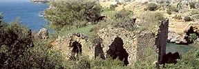
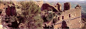
Selinus
 The city, 45 km. away from Alanya, is situated on a skirt of hill extending to the sea in elbow shape. The history of the city dates back to 6th century B.C. Roman Emperor Trajanus comes to this city when he becomes sick on the way back from a military expendition of Part in Eastern Mediterranean, and dies here on 9 August 117 A.D., his ashes later being sent to Rome. The city was called Trajanapolis for sometime. There is acropolis of the city on the hill surrounded by the city walls. The top of the hill where there is a cistern has a view of Mediterranean Sea. The Agora of the city is near the sea side. Although the Agora have been destroyed, the granite columns can still be seen. Inside the city walls, there are some ruins of a church with apsis. The church was dedicated to Saint Thekla. Another monumental building of the city is the hunting mansion decorated with 13th Seljuk period zigzag figures. This building is also considered to be built in antiqity and meant to be a tomb in memory of Trajanus. Around The Selinus creek flowing towards Mediterranean, ruins of a cistern can be seen. One of the two baths of the city is located on the part that the rocky mountain slope intersects the sea. The theatre has been destroyed. The monumental structure in cemetery which is the necropolis of the city indicates the customs of burying tradition in Kilikya. Archeological excavations in the region are yet limited to surface researches. It is possible to reach the top in half an hour’s walk. People taking the path to top are advised to have some water with them.
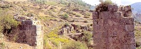
Syedra
 Located on 20 km east of Alanya. As a result of the excavations carried out by Alanya Museum, it is believed that the history of the city dates back to 7th century B.C. The city is surrounded by city walls. There are several cisterns which provided water needs of the city. The nish caved into the stone in one of the caves are decorated with frescoes. The cave must have been used for religious purposes. And is known as baptising cave. There is a wonderful bath building on the east of the town. There are mosaics on some part of the bath floor. Just on the west of the bath, in north-south direction the columned street of the town lies. There are nishes on the north walls of the street. In the excavations it was understood that the street is in 250*10 metres sizes and covered with wooden roof and south is open. There are many inscriptions about races and competition. Other important structures in the town include temple, theatre, acropolis, necropolis, agora, houses and town walls. The inscription which was prepared from Roman emperor Septimus Severus’s letter sent to the city in 194 A.D. is exhibited in Alanya Museum. In his letter the emperor expresses his gratefulness to the people of Syedra who resist the bandits and undevaut attacking the city. Entrance to the site is free. It is necesarry to walk 1 km. after the motorway finishes. Going up the hill through the scrubby land, one can see the beauty of Maditerranean and Alanya fortress.